ReForCha - Project overview
Our specific research questions are:
- How can woodland degradation monitoring be improved using multi-sensor techniques?
- How can remote sensing data be integrated in ecosystem models to assess soil degradation?
- How do land use policies affect and are affected by degradation?
Using the Dry Chaco in Argentina as an example, the central objective of ReForCha is to develop advanced remote sensing methods and indicators to:
- more reliably map forest degradation (e.g., via logging or forest grazing) and to separate it from forest conversion and natural disturbances (e.g., fire)
- assess the biophysical effects of forest dynamics on soil degradation and salinization
- evaluate whether the extent and severity of vegetation and soil degradation differ among actor groups and whether conservation policies are effective in mitigating degradation in dryland forests
The overarching goal is to integrate multi-source remotely sensed data, field observations and land surface models to enhance our insights in ecosystem degradation in dryland forests. More specifically, we aim to understand and quantify the intertwining of land-use dynamics, vegetation and soil degradation, following both conversions and subtle changes in subtropical woodlands, how these changes vary among actor groups, and how they affect land use decisions and land use policies.
Project Workplan
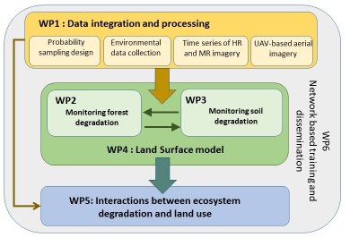
ReForCha is structured in six work packages (WP).
- WP1 comprises processing and integration of optical satellite imagery, biophysical data and unmanned aerial vehicle (UAV)-based remote sensing data.
- WP2 will improve change detection techniques to more reliably detect and monitor both conversions and gradual changes in subtropical woodlands over the last 30+ years.
- WP3 will integrate field measurements and remote sensing retrievals to track spatial and temporal changes in soil degradation and salinization, as a function of forest disturbance frequency and intensity.
- WP4 will use satellite-based dynamic vegetation data from WP2 in land surface model simulations to evaluate changes in the key biophysical processes regulating energy and matter exchange, including photosynthesis, respiration, evapotranspiration, and their effect on soil moisture and carbon fluxes.
- WP5 will evaluate how land use causes soil and forest degradation in the Argentinean Dry Chaco region, and how this degradation influences land use decision.
- WP6 comprises network-based training activities and dissemination for non-scientific audiences.

