Linking urban land use and mental illness
Linking urban land use characteristics and mental illness - a spatio-temporal analysis
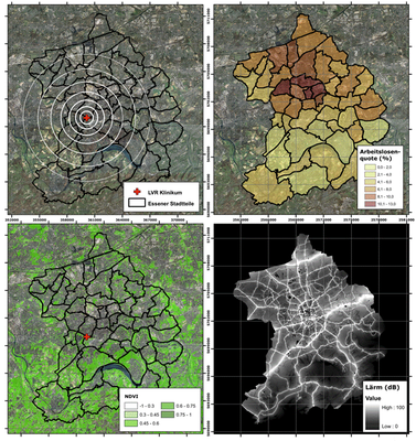
Urban living environments can directly or indirectly influence mental health by psychological distress. The aim of this project is analyse the spatial patterns of observed mental illness and the characteristics of the respective living environments. Socio-economic, demographic and environmental data the one side and observed mental illness data on the other side are explored using geostatistical techniques. Including a time series of recorded mental illnesses allows augmenting the spatial pattern analysis by a temporal dimension.
The research project is a cooperation between the Geography Department (Geomatics Lab), Humboldt-Universität zu Berlin, and the Department of Psychosomatic Medicine and Psychotherapy of the LVR-hospital Essen.

Principal Investigators:
Tobia Lakes (Geomatics Lab, Geography Department,
Humboldt-Universität zu Berlin)
Wolfgang Senf (Klinik für Psychosomatische Medizin und Psychotherapie,
Universität Duisburg-Essen)
Project Investigator:
Philippe Rufin (Geomatics Lab, Geography Department,
Humboldt-Universität zu Berlin)
Cornelius Senf (Geomatics Lab, Geography Department,
Humboldt-Universität zu Berlin)
Sefik Tagay (Klinik für Psychosomatische Medizin und Psychotherapie,
Universität Duisburg-Essen)
