Seasonal and Diurnal Use of the Fauna Bridge Wiesenhagen (Brandenburg, Germany) by Large Mammals in 2020/21 based on Camera Trap Data
Rebekka Roch
Transportation infrastructures, such as roads and railways, have numerous detrimental effects on wildlife populations. Linear transportation infrastructures lead to a loss of suitable habitats by causing their fragmentation and degradation in quality (Jackson, 2000). By impeding wildlife movements, roads exert a barrier effect on populations (Van der Grift et al., 2013) which reduces dispersal and recolonization rates as well as gene flow between subpopulations (Corlatti et al., 2009; Jaeger & Fahrig, 2004). Wildlife vehicle collisions (WVC) on roads pose another threat on the persistence of populations, as they directly contribute to the decline of populations (Jaeger & Fahrig, 2004).
Green and fauna bridges (large vegetated overpasses) are aimed at mitigating the detrimental effects of transportation infrastructures, by providing save passages over roads for wildlife and thereby improving landscape connectivity (Corlatti et al., 2009; Smith et al., 2015). To evaluate green and fauna bridges as alleviation measures, monitoring their use by wildlife is important (Jackson, 2000; Ogden, 2012). The aim of this thesis is to determine which large mammals regularly cross the fauna bridge Wiesenhagen (Brandenburg), to describe temporal patterns in their crossing behavior, and to analyze the activity overlap of human and wildlife crossings. Therefore, this thesis examines 29.923 pictures taken by a wildlife camera trap from 12.03.2020 to 12.03.2021. Activity patterns are quantified with regression models (Generalized Linear Models, GLM) and visualized in RStudio. Understanding the usage patterns of the fauna bridge may help identify suitable locations for future crossing structures and to adjust the conditions of those that already exist.

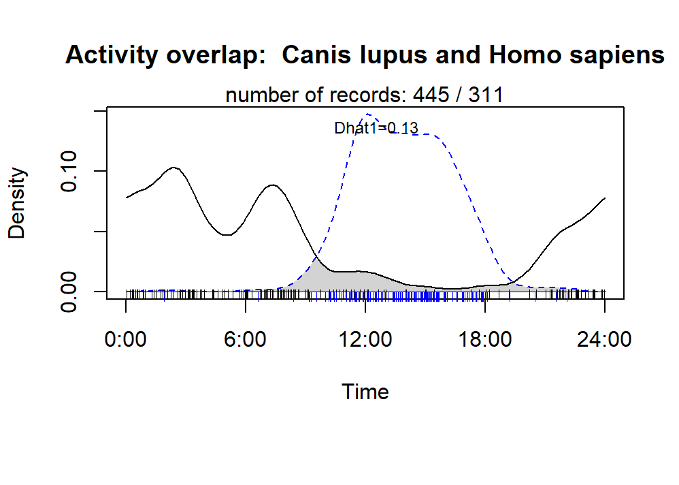
Fig. 1. Diurnal activity density overlap of gray wolf (Canis lupus) (solid black line) and human (Homo sapiens) (dotted blue line) presence on the fauna bridge Wiesenhagen, based on camera trap data from 12.03.2020 to 12.03.2021. (Created with the CamtrapR package in RStudio (Niedballa et al., 2022)) (Roch, 2022)

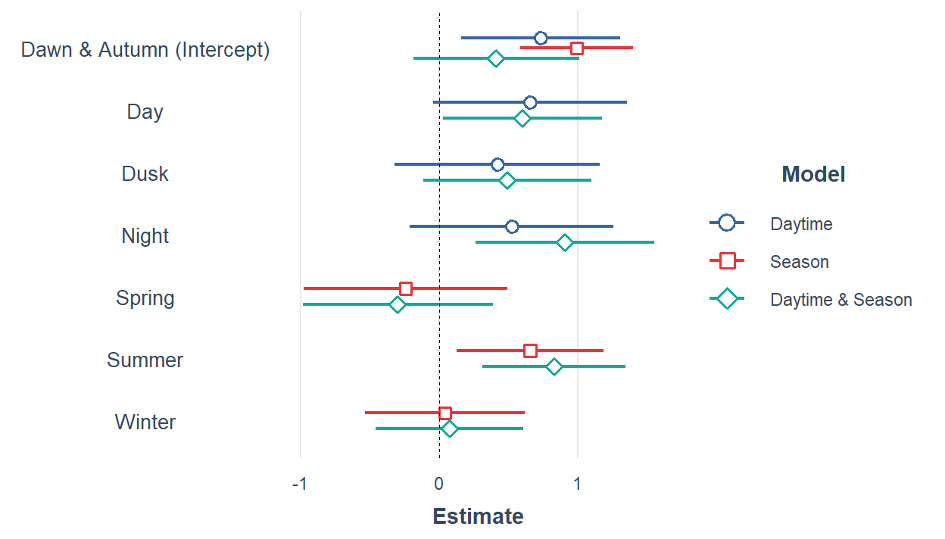
Fig. 2. Estimated model coefficients (and 95% confidence intervals) from three negative binomial GLMs, containing a function of daytime and/or season as predictors of wolf crossings. Significant predictors of crossing are those whose estimates and 95% confidence intervals do not overlap zero (vertical dotted line). (Created in RStudio) (Roch, 2022)

Fig. 3 Gray Wolf (Canis lupus) crossing the Fauna Bridge Wiesenhagen (Bluhm, 2020)

